|
For the “several-ith” (silly I know) time, we have gone over our plans and what is going in our packs. A lot of time was spent thinking about meals, snacks, and weight. Our packs are heavier than we would like but as they say “You pack your fears”. Ours is that we will not have enough food and snacks. Mostly snacks. Foreshadowing… we did carry more than needed.
It is vital that you eat along the way on a long hike. There is a real risk of the body not having enough carbs and minerals to keep going. Important for anyone but even more important for the “more mature” hiker. Final weight on our packs is 27 pounds for Shawna's and 31 pounds for mine. This is before water that will push those both up by 9 pounds each in water. Ouch! We will feel this on our hike down.
0 Comments
We are heading out soon to start our South Rim to North Rim and Back to South Rim hike of the Grand Canyon. We are backpacking for 7 days and 6 nights in the Canyon. The image below shows the trails we will hike. From the south rim we will take the South Kaibab Trail down. Then across the river and up the toward the North rim. On our return we will take the Bright Angel Trail up. 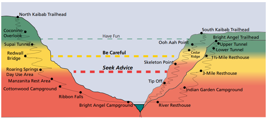 In just the last few days, we got bad news that a portion of the north rim trail is closed. The North Rim received 126 inches of snow this winter and the trail has been blocked with 10 feet of snow drifts and landslides that have completely buried parts of the North Kaibab trail for the last 2 miles to the North Rim. That will remove the last 6 miles. As a result instead of camping overnight on the north rim, we will stay an extra night at the most northern campsite on the trail. The Backcountry permit office is not allowing anyone to hike that part of the trail. It is too dangerous. They hope to have it cleared and repaired by June. We have been planning this hike since January of 2020. We do not want to wait and try again since getting the backcountry permit is so difficult. Also, we are not getting any younger. We entered the permit lottery last November and we were super excited that we got one for this April. One day, we will try to hike from the north rim down into the canyon. Rim 2 Rim 2 Rim Trail Statistics: Total Distance: 48.7 Miles Total Elevation Change: 20,000ft + Elevation Gain: 10,000ft + Elevation Decent: 10,000ft + North Rim Elevation: 8,250ft South Rim Elevation: 7,260ft Highest Point on Trail: 8,325ft Lowest Point on Trail: 2,400ft (Colorado River) Our statistics will be slightly less because we will not be able to reach the North rim. It is a bit overwhelming but we have been preparing for quite a while. There is no cell service in the canyon only at the south rim. We do have our Garmin Inreach for emergency SOS. We will be sending text messages and updates with our location using the Garmin. 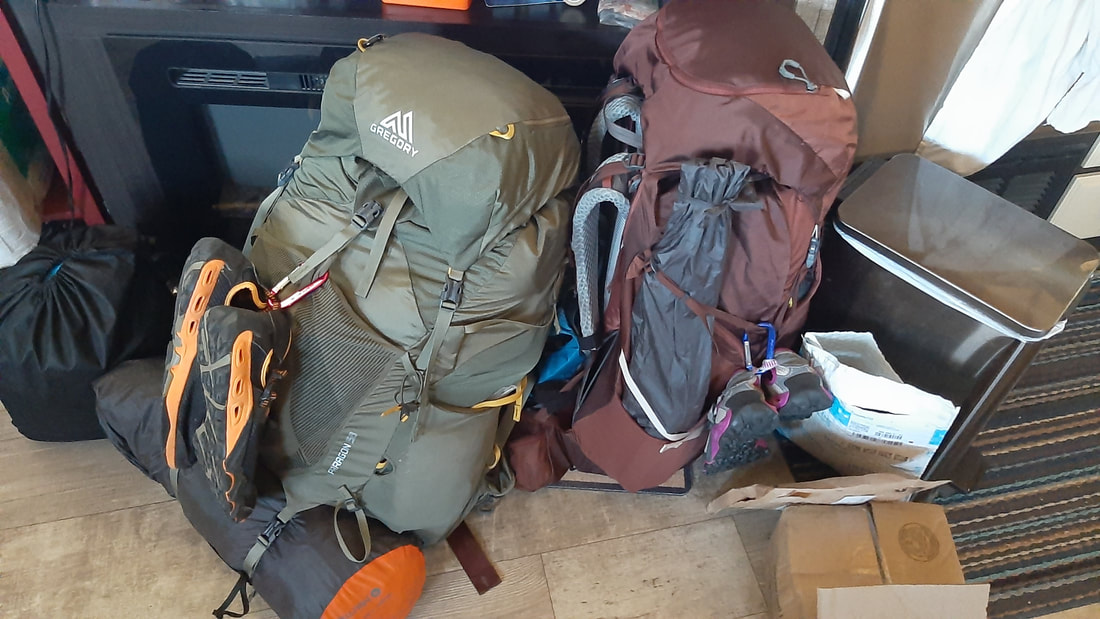 Our packs will be heavy when we start but get lighter as we progress through the hike. We will start with all our food and the water to get to the first campground. Lucky for us digital pictures don't weigh anything or we would be in real trouble. At this point, I am guessing we will take thousands of pictures.
We are so excited to finally be doing this "Bucket List Item". We have been hiking with our packs and adding weight constantly. We have them fully loaded except water. Shawna's pack is 30lbs, Mike's pack is 34lbs. We feel really good about the amount of weight. |
AuthorWe are a couple who have started on a new adventure... Archives
January 2024
Categories |
 RSS Feed