|
We were kept in by rain. A day of rest. When it stops we will get ready for the move to Marion NC in the morning.
0 Comments
We drove to Waterrock Knob to hike the trail to the top. At the parking lot, the altitude is 5,882 feet but at the end of the hike we would be at 6,292 feet.
The problem with being up that high is that many times that’s where the clouds are. As we got close to the top it was misting. When we pulled into the parking lot it started to rain, a very cold rain. The temperature fell from 82 at the RV Park to 62 on the mountain. If felt pretty chilly. So we sat in the truck and ate lunch and watched the rain. On the way back down we found ourselves dropping below the cloud deck. It had stopped raining and the temperature started to rise.
We ended the day by taking a three mile bike ride at the Oconaluftee Smokey Mountain visitor Center. It is one of only a few fairly level paths for bike riding. We were hoping to see the Elk herd but instead we just had a nice ride along the river. On the way out of the park we passed an Otter running along the side of the road. He did not give us much time to take a picture. Shy I guess.
Today we visited Franklin, NC and had a great time. The plan was to go to the three museums and a little shopping. The museums are the Macon County Historical Society & Museum, Gem and Mineral Museum of Franklin, North Carolina and Scottish Tartans Museum. The Scottish Tartans Museum was very informative. The owner was great and of course he was wearing a kilt. For anyone with Scottish heritage this is a place to visit. The Historical Society has done a great job of collecting examples of local history. Items start with Indian artifacts to Civil war and on to items when the building was a store which closed in 1972. Because this is a local museum you have so much more access to not only the displays but someone on site that can explain them. Much of the building is as it was when this was a mercantile with the exception of display cases for the exhibits. It has the original floors, counters, second floor balcony, and the front door latch. The last was the Gem and Mineral Museum. There were 100’s of examples. The largest was over 200 lbs. The smallest was gold nugget. We were really impressed with the florescent display room. The minerals were displayed in short and longer wave length light. Some glowed with one color under short and a different color under long wave lengths.
Not to have anything different from any other day, it started raining. Now a treat, we went out to dinner at a local restaurant that serves farm to table. This is when as much as possible all ingredients are from local farms. We had great food and not very expensive. Off to Walmart to restock and then home.
We hiked a combination of trails to see 3 falls and several creeks today. The falls were nice but not as impressive as some we have seen but with the combination of creeks and scenery it was a great hike. Part of the hike was along a horse trail around the mountain. This caused some side steps to avoid “deposits” on the trail left by horses. Near the end we walked beside a creek being used by people tubing. They were having a great time.
Well the pantry and fridge were getting a bit bare so we took a day to go shopping. Asheville has the closest Sam’s Club among other stores we wanted to shop then we drove back to Sylva to finish up with what we needed. For those who asked here are a few pictures of where we are currently staying. The fog on the mountain and Black Eyed Susan’s we can see from the table. There is also a picture of the view out our rear windows and the spot where we are setup. The creek is just behind the camper and when we open the windows we can hear it splashing over the rocks. The "wild life" in the park are chipmunks, butterfly's, box turtles, and at night firefly's.
Today we hiked the Smokemont Trail. Total length of the hike was 6.5 Miles and the total elevation gains 1441 Feet. The highest point is 3641 Feet.
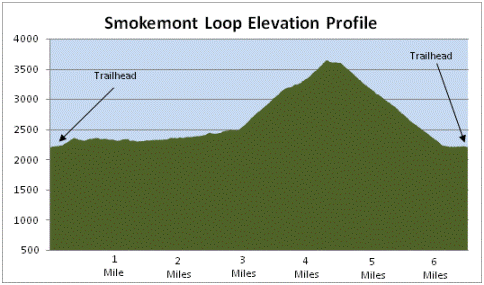
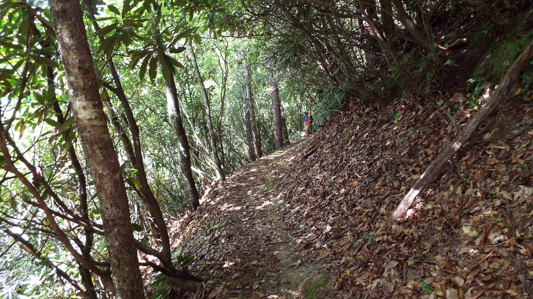
It starts out pretty easy and very little is uphill. For the first part of the trail it follows along a creek. After that things got interesting. The trail crossed the creek using a tree with the top shaved flat. It did have a rail on one side.
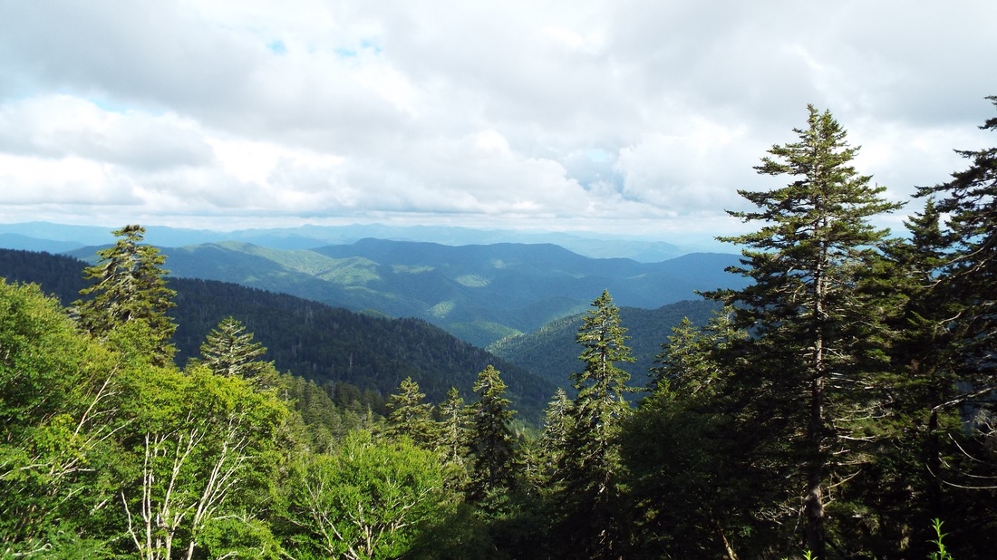
At this point the trail becomes pretty narrow and quickly starts to climb. At times it was like some of our other hikes. A mountain on one side, two feet of trail, and falling away several hundred feet on the other side. Still really pretty.
Of course if we go on a hike it rains. Just as we reached the high point and started down it started to pour. We put on our emergency ponchos and continued on down the mountain in soggy shoes. We always carry a backup set of clothes and changed into dry shoes and clothes once we finished the hike.
And now our video of the hike... Treating every day as a vacation day is exhausting. It is one of the common warnings by full time RVers. Being in a location where there are so many things to do and see it is tempting to do something everyday. Doing this means no time to rest and recover, clean house, wash clothes, etc. So we took a day for those things. Of course while Shawna was at the RV parks laundry I washed the truck and RV. It was not like we could really just sit and do nothing was it?
We decided to take a break from hiking and drive part of the Blue Ridge Mountain Parkway. At almost every turn there is a view of the mountains and there are plenty of overlooks to stop take pictures and enjoy the view. At a few stops there were lots of wildflowers and butterflies.
No matter what I tried I could not capture the drop off at the edge of the overlooks. The grass was mowed right up to the edge of a drop off that was just short of vertical. About a 10 foot drop for every 2 feet out and continuing for sometimes 500 feet like that. It is deceptive because of the thick grasses, weeds, and wildflowers growing up above the cut grass sometimes made it look like the edge was several feet further.
Below is the full raw video of driving the Parkway. We did stop the camera almost every time we pulled off on an overlook. It is long and we did not talk much of the time. I did not think adding music would improve the video. ....
We stopped at the restored 1900’s farm at the Oconaluftee Visitor Center to the Smoky Mountain National Park. The farm has several buildings including a set of log bee hives. The barn is huge and still water tight. Rain poured down for half an hour on our tour. So that was where we waited till it cleared. The turkeys in the field were not concerned about our being near them at all.
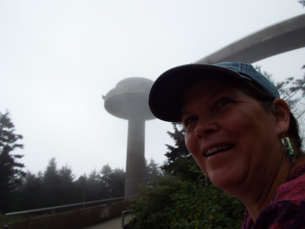
We drove into the Smokey Mountain National Park and stopped off at the visitor center to ask a few questions about hiking. They had a “day hike” map that is very helpful. After that we went on to Clingmans Dome which is the highest point in Tennessee at 6,644 feet. The drive from the RV Park to the top climbed just under 4,000 feet.
The drive into the park is great. Beautiful views of rivers along the road, thick forests, and overlooks that show the other mountains and ridges in the Park. As we drove up Clingman we found ourselves driving up into clouds. So the Smokey’s were just as you would expect – Smokey. The video at the end of this post shows more of that.
The temperature when we left the RV was 82. When we got to the top of the mountain it was 63. When we got back home it was 84. Not only was it cool but the wind was strong and it was misting. Well we were in clouds so that was no surprise.
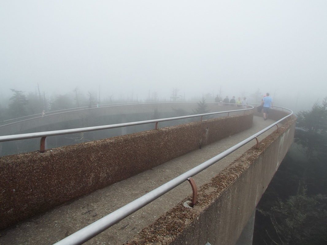
From the parking lot there is a pretty steep climb for ½ mile to the base of the observation tower which is another 54 feet tall. There were wild flowers all along the trail. It was Saturday so there were plenty of people going up and coming back from the top. Appalachian Trail climbs up Clingmans Dome and while we were eating lunch several people came up from the trail to the top. It is the highest altitude of the trail. From the top of the tower we got a view of the very top of the mountain directly below us but everything else was hidden by clouds. The tower is holding up great considering it was build the same year we were born, 1959.
We hiked from the top of the mountain to Andrews Bald which is the highest bald in the Great Smoky Mountains.
It was interesting hiking to the trail well laid out. The path was crisscrossed by small streams or properly named ‘Cricks’. The difference is if you can jump over it without getting wet it’s a Crick. We passed through a thick forest where there were a lot of moss and ferns.
A bald does not mean literally empty but a small area with no trees. The area was thickly grassed and had dozens of blueberry bushes. All of which seemed to be picked clean of mature berries. Seems the bears had been busy sometime recently.
There was a problem with traffic. This little guy was crossing the stones in the path. As always animals have the right of way. It is their home. We are just visiting.
The hike is 3.4 miles to the end and then back to the parking lot with a change of 650 feet in altitude. Of course that means you have to walk back up that same amount. Total we hiked just over 4.5 miles.
Exhausted but happy to have made the hike we returned to the RV.
Here is the video of our visit.
We move the RV from north Georgia to North Carolina near the Smoky Mountains.
The truck got 9.8 MPG. It was a much more difficult pull up the mountains. The RV park is older with half as permanent but very nice and well maintained. |
AuthorWe are a couple who have started on a new adventure... Archives
January 2024
Categories |
 RSS Feed